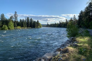
This narrow strip of land just east of Port Angeles in the Strait of Juan de Fuca is a gorgeous place to explore miles upon miles of sandy beach, spy shorebirds wheeling, and even get a little shot of greenery at the beginning and end of your trip. But remember, while the beach is usually a good place for dogs to get some exercise, this particular one is closed to pups, since it’s a National Wildlife Refuge.
Beginning at the large paved parking area, look for the large informational kiosk where you can pay your entrance fee. It’s $3 per family or group (which includes up to 4 people). Once you’ve done that, head into the cool forest.
Overhead, the forest canopy is lush green, with mosses and leaves working together to protect you from direct sunlight as you descend to the shore. Make your way past knee-high salal and other understory, keeping one eye on the thick greenery above your head. The way is somewhat steep, as it loses 130 feet in less than half a mile, but once you arrive at the beach, it’s a delightful flat walk all the way to the lighthouse five miles from where you stand. If you arrive at the lighthouse during visiting hours, there is a small museum and a public restroom. The facility also has picnic tables, running water to refill your water bottles, and a garbage can for disposing of collected beach debris (pack out your own waste).
Along the way, look out for a myriad of shorebirds. You’ll likely spy harlequin ducks and plovers, as well as dippers and of course the ever-present seagull. The best time to visit Dungeness Spit is at low tide, when there’s more land to walk on. If you’re here at high tide, simply be aware of the driftwood – it may not be as sturdy as it seems.
WTA Pro Tip: The land past the lighthouse and the land bordering on Dungeness Bay (the other side of the narrow strip of land you hiked out on) is closed to visitors. It’s a protected area for the wildlife this refuge was established for, so please respect the closure.
Dungeness National Wildlife Refuge - Dungeness Spit

-
 Length
- 11.0 miles, roundtrip
-
 Elevation Gain
- 130 feet
-
 Highest Point
- 130 feet
This narrow strip of land just east of Port Angeles in the Strait of Juan de Fuca is a gorgeous place to explore miles upon miles of sandy beach, spy shorebirds wheeling, and even get a little shot of greenery at the beginning and end of your trip. But remember, while the beach is usually a good place for dogs to get some exercise, this particular one is closed to pups, since it’s a National Wildlife Refuge.
Continue reading
Hiking Dungeness National Wildlife Refuge - Dungeness Spit
Map & Directions
 Trailhead
Before You Go
Parking Pass/Entry Fee
Refuge Entrance PassWTA Pro Tip: Save a copy of our directions before you leave! App-based driving directions aren't always accurate and data connections may be unreliable as you drive to the trailhead.
Getting There
From Port Angeles, drive east on Highway 101 for 12 miles. Turn right at milepost 260 onto Kitchen-Dick Road. At 3.3 miles, the road makes a sharp right and becomes Lotzgesell Road.
Continue for a quarter mile, and then make a left onto the patriotically-named Voice of America Road. This road is signed for the Dungeness National Wildlife Refuge, and Dungeness Recreation Area.
Continue through the County park and campground. The trailhead is found one mile down this road, where there are restrooms and potable water available. The refuge has a $3 entrance fee, which covers groups up to 4 people.